
History of the Lower Verde River Valley and the Central Arizona Project (CAP)
(Rusinek 1989, 224)
In “Battle for the Verde River: Arizona’s Other River Controversy,” Walter Rusinek examines a history of development plans of the Verde River to divert water to serve the city of Phoenix, Arizona and its surrounding areas.
The first plans for the Rio Verde Canal project began in 1889 when a Christian community was envisioned by John Hudson. He portrayed the Verde project as one “that would be ‘an object lesson’ to the Christian world, a true ‘Paradise’ Valley, and he promised that profits from the sale of water right and hydroelectric power would support missionary work worldwide” (Rusinek 1989, 225).
In 1890, investors from Minnesota formed the Rio Verde Canal Company who had plans to diver water from the Verde River to Paradise Valley. However, an economic depression int he “1890s” that “collapsed” the Rio Verde Canal project. Despite the collapse, Cincinnati group, the Verde Water and Power Company purchased the project.
In 1903, the federal government selected the Salt River Valley as the site for one of the nation’s first reclamation projects (which resulted in the construction of the Roosevelt Dam and the Salt River Project). By 1910, the Kent Decree determined that the Verde Water and Power Company did not have any water rights and the project, characterized by Rusinek as a “blend of optimism and economic/technical unreality” (Rusinek 1989, 226), failed again. The decree did not account for flood flows or future storage of the Verde River which remained a contention and later served as a strategic move to preserve water flow for the Salt River project (Rusinek 1989, 229).
During the stock marked crash of 1929, unlike the previous depression, the Verde project gained support as a way to supply water to the Salt River and Camp McDowell reservations. Since 1916, Congress had appropriated money to provide water to the Salt River Reservation through the Salt River Users Association, however, the group claimed there was no excess water nor was any sent to the reservation. At this same time, non-Indian irrigated acreage expanded (Rusinek 1989, 237). A proposed solution to avoid taking surface water from white farmers was to provide ground water to the reservation which was rejected based on the same reason that white farmers did not want groundwater – the high alkalinity made the groundwater unusable for farming (Rusinek 1989, 237). In 1930, an agreement was formed with the Verde district granting it right-of-way for canal access across the Salt River Reservation.
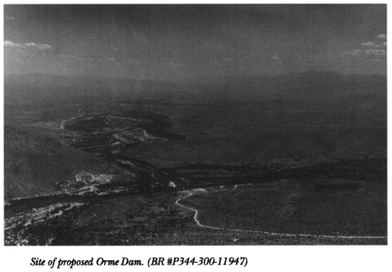
As for the Fort McDowell Yavapai, in 1903 the Camp McDowell Indian Reserve was established along the Verde River. The creation of the Salt River Valley Users’ Association as well as the construction of the Roosevelt Dam in 1905 generated interest in controlling the Salt and Verde River resources. Federal officials attempted to convince the Yavapai to move to the Salt River Reservation. However, Yavapai physician, Carlos Montezuma, warned that there were engineers around the Verde Valley and that a dam was planned to be built at the confluence of the Salt and Verde rivers (Shilling 2000, 59). The Yavapai’s access to the Verde River came into questions in the late 1960s with the proposal of the Orme Dam project.
Some day a dam will be built and the McDowell land will be flooded and the water will be used for drinking water for the Salt River Valley people. No wonder the McDowell Indians are hoodwinked and urged to move to Salt River reservation. White people’s heads are long; they can see many years ahead.”
Carlos Montezuma, (quoted in Shilling 2000, 59).
Fort mcdowell Yavapai nation, Orme Dam, and CAP
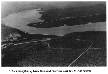
The proposed site of construction of the Orme Dam was on the Verde River in the Lower Verde River Valley which would divert water to the Phoenix area. Also at this site is the Fort McDowell Yavapai Nation and the dam would have flooded 2/3 of the reservation. The Bureau of Reclamation was prepared to offer the tribe $33 million dollars and rights to the recreation concessions from the planned reservoir behind the dam (Espeland 2001, 405).
However, there were many issues regarding recreational reservoir emerged when it was revealed in 1963 by the US Bureau of Reclamation that the lake behind the dam would fluctuate up to 65 feet. Fort McDowell tribes expressed that the low water level “’will be surrounded by a mud flat’ and at normal water level the lake would be so shallow that it would be ‘of very little use for recreation of any sort’” (Shilling 2000, 61). Furthermore, Natives and the Bureau approached the dam site from two disparate worldviews. The Yavapai were not interested in selling their land because they felt there was no price on something that they considered sacred and they explained that “losing their land would mean betraying their ancestors” (Espeland 2001, 405). The Yavapai also stated that the Bureau should “start treating the Salt River and Ft. McDowell Indians as adults and not [as] naughty and backward children” (Shilling 2000, 61).
Yavapai organized in protest of the Orme Dam and were able to rally support from many other organizations including the Maricopa Audubon Society, US Fish and Wildlife Service, Citizens Concerned About the Project (CCAP), and later support from religious and civil rights organizations (Shilling 2000, 67). The resistance the Orme Dam project met stemmed from a conflict between development and culture.
Brogden and Greenberg explain that “the commoditization of certain elements within natural systems subjects them to a different logic — that of the market — where decisions regarding resources are severed from a perception and understanding of their role within ecological system functioning” (Brogden and Greenberg 2003, 290). Outside of Western colonial frameworks, the “value” of land cannot be defined as something with monetary costs. Furthermore, the Yavapai, along with other indigenous groups, had a history of federal promises that were never implemented.
By 1976, a draft of the environmental impact produced by the Bureau of Reclamation which warned of geological faults and potential downstream hazards (Shilling 2000, 77). The problematic site combined with strong community resistance led to the defeat of the Orme Dam project in 1981 (Espeland 2001, 424).
Evident in the politics of the Verde River are the conflicts between multiple entities with different objectives and values. As Espeland explains, the Orme Dam threatened Yavapai collective identity, cultural legacies, and future (Espeland 2001, 421).
“If we took the money we could not be ourselves…and we could not live with ourselves.”
(Quoted in Espeland 2001 from Espeland 1998, 205)
Brogden and Greenberg further explain that “where ecological problems arise, they often entail multifaceted legal and political disputes that may involve a host of local, state, and national bureaucracies. In such disputes, local communities and users, who often are both the most dependent upon and the most knowledgeable about the resource, have difficulty achieving voice” (Brogden and Greenberg 2003, 291). Certainly, the cultural, political, and economic complexities of managing the Verde River is an issue that will continue to be contentious. With population growth in Central Arizona and competing interests, water access and distribution will be continuously contested and renegotiated.
